

After dropping the home owners off at Granada airport at the start of our most recent house sit in Spain we decided to stop off at Moclin – a hillside village with a 14th century Moorish castle overlooking a valley towards the Sierra Nevada.
The GPS guided us off the main highway and up a winding 5km road towards the village. Many of the roads here are not particularly wide so traversing every blind corner is an act of faith hoping that if a car is coming the opposite way they are at least on ‘their’ side of the road! We made it to the village without incident and then had to make our way up to the castle along even narrower roads. As we are here in May we are out of the tourist season and thankfully there were very few people about ie. none, (particularly on the roads) and parking was no problem. We wandered up to the castle gates to discover to our dismay that it was only open on weekends.
Returning to the car we saw signs for the ‘Ruta del Gollizno’ – we had no idea what this was so decided to take a look. Before departing the home owners had mentioned that near Moclin there was a nice walk with views down the valley and a suspension bridge over the river in the valley so we assumed that this must have been part of this trail. We found a large map (all in Spanish of course) and had difficulty deciphering it but did determine that the walk was over 15km, up hill and down dale, and we weren’t really prepared for that type of hike on that day. We decided to return another day better prepared.

Fast forward a couple of days and we were back, prepared and ready for our big hike. We’d found some limited information on the internet prior to leaving but a lot of it was ambiguous and some of the translated reviews indicated it was only a 5 mile (8 kms) loop with a 350 metre vertical descent and 350 metre ascent. So we headed off on a beautiful sunny day with snacks, water and camera down the steep track into the valley.
0.7 km – Mirador
About 700 metres down the path we came across the first ‘stop’ – the Mirador (viewpoint) and it offered nice views up and down the valley. In one direction was the steep, rocky landscape that we would enter in a few kilometres and in the other a magnificent view over the village of Los Olivares, the rolling hills and the, still, snow capped peaks of the Sierra Nevada in the distance.


1.2 km – Ermita de las Angustias
We continued the very steep descent for another 500 metres and came across a small chapel – the Ermita da las Antiguas. It too was closed but we were able to peek inside through the small open window.

2 km – Recreation area
This hike is very popular with locals on the weekends and 2 kilometres in there is a large picnic area with tables and chairs, water, toilets and small kiosk (which was of course – closed).
Not far from the picnic stop we were almost at the valley floor and the trail entered the outskirts of Los Olivares. There was no signage for where we should continue so we asked a local lady (in our very poor Spanish!!) who pointed us in the right direction. A little farther on the path finally emerged next to the River Velillos. The environment was now much more pleasant than the dry, rocky, steep dirt path we had experienced to date. Lush vegetation lined the banks of the river and bird song was all about us.
3.5 km – first bridge
After 3.5 kilometres we encountered the first bridge crossing the river and after walking a further 300 metres we came across the first ‘watering hole’ – the Fuente de la Beuna Ventura. We took in another great view, had a short rest, filled the water bottle and pressed on.

3.8 km – Fuente de la Buena Ventura


4.4 km – Puente Colgante – suspension bridge
The trail started to climb and the vegetation along the path opened up as we left the valley floor. Another half a kilometer and we viewed the second river crossing ahead – the Puente Colgante, a suspension bridge quite high above the rocks and river. After the obligatory photos and selfies (we don’t take too many of these) we crossed the swaying, bouncing timber and steel cable bridge. This area appeared to be the narrowest section of the gorge with solid, tall rock sides and no option for a path. To overcome this a ‘hanging’ timber board walk attached to the cliff wall had been installed. It was quite cool walking along this and we could only imagine how spectacular it would be during the winter when the river would be full of rushing water.

5 km – the ascent starts
At the 5 kilometre mark the trail started to climb steeply with a series of switchbacks but fortunately there were some rope rails on the track to make things a little easier. After a short ascent of about 300 metres we ‘popped’ out of the valley and were now looking from a Mirador at a lovely vista of rolling hills, olive plantations and a small village in the distance.

5.3km – Mirador

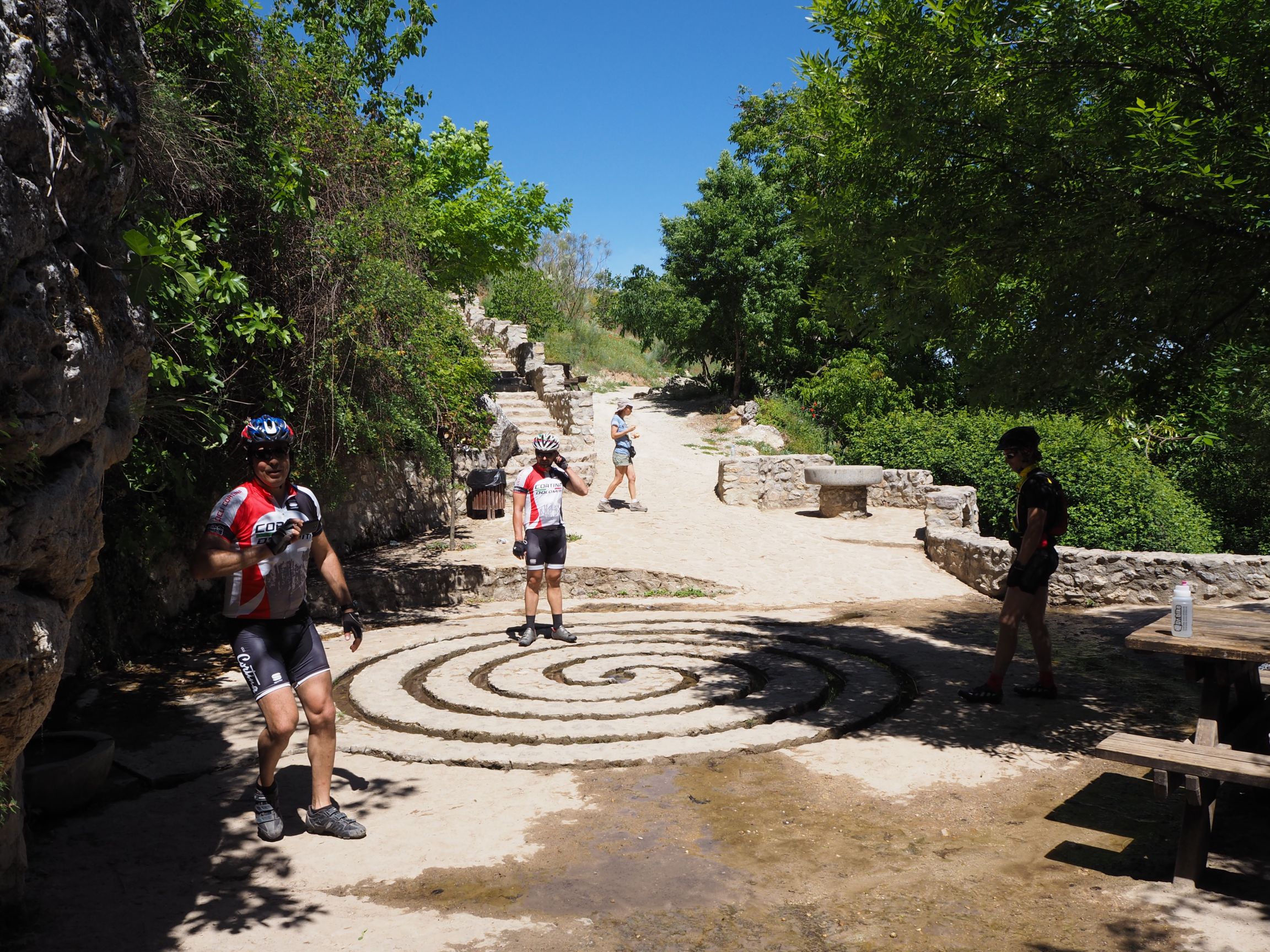
5.7 km – Fuente de Corcuela
A short distance further on we arrived at the Fuente de Corcuela – the source of water for the river. There was a nice shady area and picnic tables and a very interesting water ‘drain’ that provides a bit of an optical illusion. The water enters at one end and exits the opposite end but looking at it it appears as if the water just goes in!! I had to walk around the labyrinth channel to work it out. Take a look and see if you can work it out.

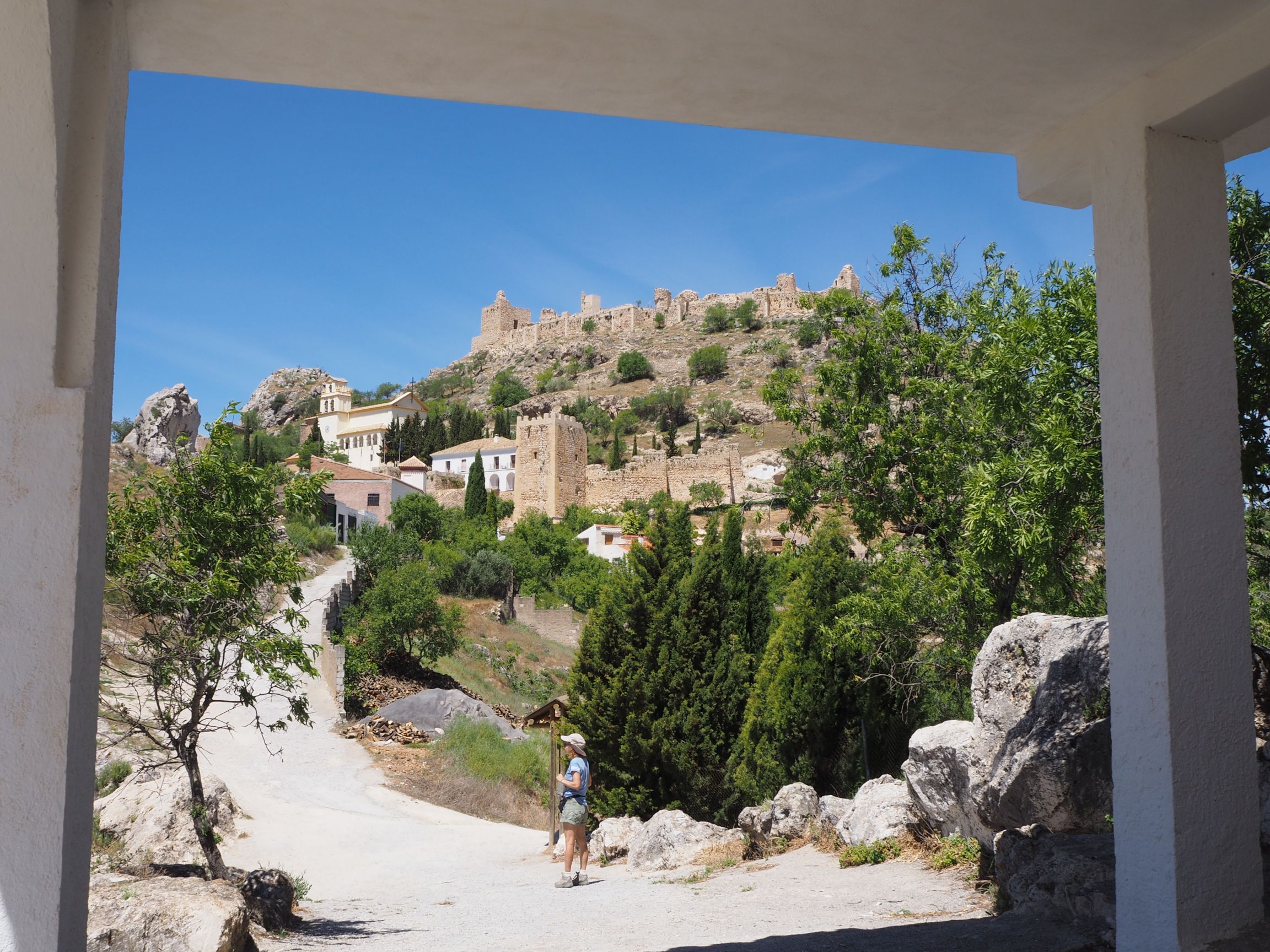
We had a well earned rest here before the last strenuous uphill kilometre where the trail emerged at another chapel – the Ermita de San Anton sitting just below the imposing Moclin castle.
6.8 km – Ermita de San Anton
With the walk over we wandered (downhill) back into the little village of Moclin eager for a drink (ie. beer) and a bocadillo (bread roll with filling). Unfortunately, the one and only local cafe in the town square was closed for some reason so we just meandered back to the car and headed home after a great couple of hours on the Ruta de Gollizno.


When you’d like to travel but can’t (for whatever reasons), what better way of seeing and experiencing places than to ‘travel’ with someone else via their photos and blogs.
Thanks Glen and Jacquie for sharing your wonderful overseas adventures. Looking forward to new instalments 😊
LikeLike
Hi Andrew, glad you’re enjoying our travels with us. It gives us great joy to know that other people are following and taking a ‘virtual’ holiday with us. Enjoy the ride….
LikeLike